The pandemic has accelerated the use of contactless drones for comprehensive applications in real estate development.

Quadcopter drone systems specialized for mapping, available for under $10,000, provide affordable aerial photographic imagery. (Dronebase)
In recent years, drones have increasingly provided affordable aerial photographic imagery that was previously performed using less-maneuverable and less-agile airplanes and helicopters. Drones initially were used primarily for marketing, but developers are discovering new ways that drone applications can improve results at multiple stages of real estate acquisition, planning, design, development, finance, construction, marketing, leasing, management, maintenance, repositioning, and sale.
Since the Federal Aviation Administration (FAA) authorized the use of commercial drones in June 2016, their use has grown significantly, and the global market for their use in the real estate and construction industry has been projected to reach a cumulative market value of $20.5 billion by 2025. Professional service firms use drone pilots who are specifically trained and licensed, and imagery costs may range from a few hundred dollars to several thousands of dollars.
Companies like San Francisco–based DroneHive often use software data analytics to augment aerial imagery, particularly for applications that require regular inspection and monitoring.
With declining drone pricing and an increasing number of applications, some real estate developers have established in-house drone teams. FAA rules permit operators to fly drones under 55 pounds (25 kg) at altitudes below 400 feet (122 m). The FAA also requires operators to obtain a remote pilot certificate, which demonstrates that operators understand the regulations, operating requirements, and procedures for flying drones safely.
Drone manufacturer DJI, based in Shenzhen, China, makes the Phantom 4 RTK, a quadcopter system specialized for mapping and priced under $10,000. Since drone service companies typically have sophisticated artificial intelligence programs and expert analysts for such things as roof inspections, they now permit clients to upload their in-house drone teams’ images for professional analysis and comparison. While drone package deliveries have received widespread press coverage, they remain mostly in testing phases.
With the impetus of the pandemic, developers may expect increasing use of drones in almost all aspects of real estate. Impediments imposed by the pandemic to traditional travel to multiple places for on-site human inspection by stakeholders, investors, planners, architects, surveyors, engineers, contractors, lenders, appraisers, insurers, government officials, and other parties have accelerated the need for technological solutions that drones can provide with more flexibility, higher quality, and lower expense than with traditional methods.

Click to zoom. Photogrammetry captures a large number of overlapping high-resolution photos and uses triangulation to generate a 3-D map. By contrast, a LIDAR sensor emits pulses of laser light and measures the exact time it takes for these pulses to return, thereby generating precise measurements. It can capture building structure and helps in wetland and brownfield delineations. (Wingtrax)
Ubiquitous availability of online satellite imagery by Google Earth, Google, Apple, and Bing Maps has vastly improved developers’ ability to visually assess locations for potential acquisition and development. But the dates of such images vary widely, and the images are static as of the dates of infrequent flights. Also, the imaging is not targeted specifically to the assessment of a property for potential development.
By contrast, drone imagery can be current, repeated at regular or specific intervals, and used to chart progress during development. Repetition at specific intervals can reveal a time-based series of patterns that are difficult to produce by other means. The aerial images can be at higher resolution than satellite photography and they may be combined with a variety of sensors, such as passive thermal and active infrared sensors, telescopic zoom cameras, and pulsed laser LIDAR (light detection and ranging) to make very specific measurements of property conditions.
In addition, the images may be combined with artificial intelligence systems to read, compare, analyze, and pinpoint anomalies and to identify changes in conditions over time. The imagery can produce surveys and contour overlays and may be combined to produce panoramic images and orthomosaics (those that are corrected for lens distortion, camera tilt, perspective, and topographic relief to form a uniform scale across the image). Such imagery can provide survey-level data at a fraction of the cost of using on-ground crews.

Drone imagery can produce surveys and contour overlays and may be combined to produce panoramic images and ortho-mosaics, which are corrected for lens distortion, camera tilt, perspective, and topographic relief to achieve a uniform scale across the image, as shown above comparing perspective and orthographic views. (Dronebase)

Drone aerial images can be combined with a variety of sensors, such as passive thermal and active infrared sensors, telescopic zoom cameras, and pulsed laser LIDAR, to make very specific measurements of property conditions. This helps in wetland and brownfield delineations. In addition, the images may be combined with artificial intelligence systems to read, compare, analyze, and pinpoint anomalies and to identify changes in conditions over a series of images. (ID-LiDAR-CR-Xi Li-Univ. of Toledo)
Site Selection
Developers contemplate the wide range of uses of drones to rationalize and improve the development process, especially in the wake of the pandemic, which has created considerable distress in many property sectors. Since surface parking is still predominant and easily visible, and since the pandemic has diminished public transit ridership in favor of cars as protected spaces for mobility, traffic and parking patterns may reveal relative strengths and weaknesses among property competitors for different markets. And since quantitative market research is more time-consuming than visual imagery and deals with lagging indicators compiled over time, drone imagery may be a faster and more intuitive way to reveal changing patterns.
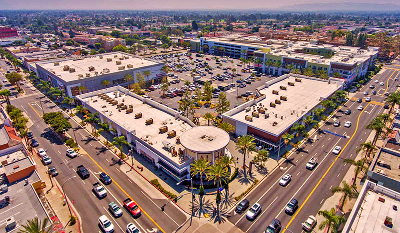
For example, many retail centers have suspended operations, deferred rents, and lost tenants due to sudden and massive changes in consumption patterns. To gain a comprehensive overview of the current condition of multiple competing centers, the most effective way may be to compare and contrast such centers in real time, comparing actual use patterns that can be revealed through traffic and parking patterns at similar times of the day, week, or season.
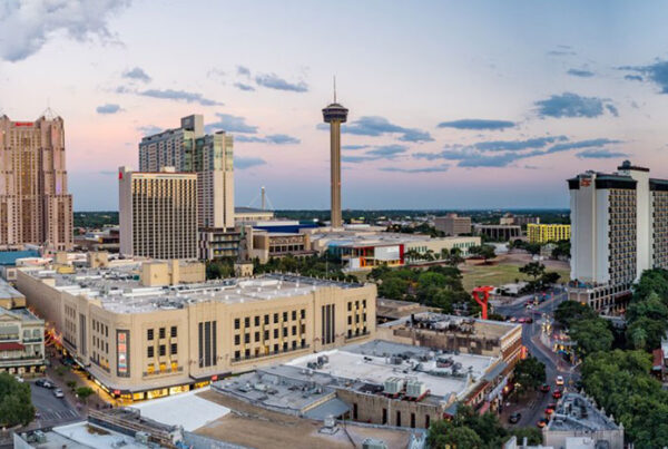
While assessing multiple retail sites at different times might be the most obvious use of drones, observing office locations, especially office parks, could be effective to the extent that traffic and parking patterns reveal which office parks retain and attract larger numbers of users. Suburban hotels, which exhibit daily occupancy fluctuations, also could be good candidates.

Drones can be particularly useful in monitoring progress in construction of high-rises. In the early stages of design, viewshed studies can greatly influence floor plate design, showing which views to optimize and which to avoid. Accurate views at specific elevations can show where to place windows and balconies, which, in turn, can be reflected in projected price and rent levels. (Aerial Innovations SE)

Aerial views of retail centers can yield comprehensive images of traffic capacity and congestion, entrance locations, parking demand and supply, roof conditions, and neighborhood context. (Dronegenuity)
Traffic to industrial sites may show which locations experience greater use as distribution centers for increased rapid individual package delivery of goods. For example, demand has increased for refrigerated warehouses closer to denser populations that have surge capacity to accommodate food deliveries to homes.
Since housing occupancy fluctuates less rapidly, multifamily projects’ parking variation could be less dramatic. But the ability to show differences among competing projects, with different local and neighborhood amenities, could reveal residential tenants’ preference patterns. With increased migration away from cities to suburban areas stimulated by widespread remote working, drone imagery of competing neighborhoods can reveal changing growth patterns.
Planning
Since the predominant pattern for land use permitted by planning and zoning codes is still single-use districts, one might expect less variation to be revealed by drone imagery. However, progressive planning changes are beginning to change that. With a 2019 statute, Oregon became the first state to require cities with populations greater than 10,000 to allow duplexes on lands zoned for single-family, and in those with populations greater than 25,000, to allow townhouses, cottage clusters, duplexes, triplexes, and quadplexes on lands zoned for residential uses within urban growth boundaries. Drone imagery could be the most effective way to identify promising locations in which to plan and develop higher-density housing that provides more privacy than multifamily projects, while eliminating shared spaces that have been spurned during the pandemic.

The combination of drone imagery with artificial intelligence and data analytics can be used to calculate capacity for solar arrays. (Dronegenuity)

Once construction has begun, stockpiles of materials and equipment can be stored on site in a way that can be accurately monitored with drone images, helping ensure security and reduce pilferage and waste. Progress on large-scale projects, like this tilt-up industrial building, can be captured and communicated quickly. (Dronegenuity)

Impediments imposed by the pandemic to traditional travel to multiple locations for on-site human inspection by various parties have accelerated the need for technological solutions that drones can provide. (Dronegenuity)
While such legislation is still restricted to residential uses, recent preference patterns of millennials for walkable mixed-use environments have spurred substantial changes in formerly suburban communities for larger scale “surban” mixed-use development. Drone imagery can reveal which larger sites, such as retail centers or office parks, could be attractive locations for surban development that is close enough to urban amenities to integrate into walkable environments that can build on the gridded infrastructure of the original towns and villages that were absorbed into metropolitan areas. When such projects are commenced, drone imagery can be used to update a wide variety of stakeholders, investors, owners, contractors, lenders, insurance companies, and municipalities interested in these projects, which often involve public/private partnerships.
Parking and Traffic Analysis
Use of drone imagery is ideal for parking and traffic analyses. Unlike the static aerial images that show parking supply and demand at a single time, the ability to undertake multiple images correlated to time of day, week, or season creates both a visual and quantitative tool to measure actual patterns of parking supply and demand. These can function as a kind of time-lapse imagery of project operation. Some drone services, like Toronto-based SkyDeploy, integrate artificial intelligence software to measure and quantify changes over time.
Such patterns can also reveal how much parking area could be reused for different purposes without adversely affecting existing operations. Different uses can be integrated into the site that can take advantage of shared parking, which, in turn, can maximize synergies, land use productivity, and profitability while expanding municipal tax bases. Visual evidence of empty parking spaces can be compelling evidence for developers trying to convince officials and lenders to reduce parking requirements.
In more urban situations, drone imagery can be used to show use patterns of on-street parking that can lead to parking management policy changes to increase use to support surrounding land uses, thereby freeing up off-street parking lots for more productive purposes. Since the public is the largest owner of parking spaces through its on-street parking network, comprehensive analysis and surveillance can lead to far more efficient use of public resources.
Denser cities explore real-time efficiency solutions. To stimulate solutions to reduce urban traffic congestion, Siemens Mobility solicited proposals in 2015 to use “quadcopters to find free spots, the shortest path to those spots, and finally [to] guide the driver to the best spot.”
Drones can also track and reveal traffic congestion flow patterns specific to time and location that can reveal better sites upon which to develop potential projects. They may also suggest the most appropriate locations for entrances to projects, road conditions that may need to be improved, lane capacity, or traffic light locations and sequencing that can be optimized.

Many retail centers have suspended operations, deferred rents, and lost tenants due to sudden and massive changes in consumption patterns. To gain a comprehensive overview of the current condition of multiple competing centers, the most effective approach might be to compare and contrast such centers in real time, comparing actual use patterns that can be revealed through traffic and parking patterns at similar times. Such images also can reveal portions of the site that could be redeveloped. (Dronegenuity)
Project Design
Drone imagery is particularly helpful in project design. Visualizing the whole site, as well as its constituent parts, from different perspectives is difficult with an in-person, on-the-ground site visit. The sophistication of current cameras and software enables detailed site-mapping and the ability to export contour maps and three-dimensional (3-D) imagery. Service companies like Santa Monica, California–based DroneBase use LIDAR and photogrammetric aerial data to produce mapping accuracies to the centimeter level. Photogrammetry captures a large number of overlapping high-resolution photos and uses triangulation to generate a 3-D map. By contrast, a LIDAR sensor emits pulses of laser light and measures the exact time it takes for these pulses to return, thereby generating precise measurements. It can capture building structure and helps in wetland and brownfield delineations.
Designers can use these images as base maps upon which to model alternative project designs. Viewshed studies can greatly influence floor plate design showing which views to optimize and which to avoid. Accurate views at specific elevations can show where to place windows and balconies, which, in turn, can be reflected in projected price and rent levels. Shadow mapping from surrounding buildings and from proposed designs can influence where to place public outdoor spaces. And drone imagery can be critical to identify optimal sites on which to place solar arrays for maximal insolation.
Such specific data are also critical for site design, erosion control, slope measurement, and drainage patterns, and give the most accurate assessment of current vegetation. Jake Fingert, general partner at New York– and Washington, D.C.–based Camber Creek venture capital firm, which invested in property technology companies, notes that such terrain data “can help potential purchasers evaluate challenging issues, like how the property would fare in a flood.”
Construction
Engineers and contractors involved in design-build projects can model alternative solutions to problems raised during design that are revealed using drone imagery. As a project reaches construction staging, such data can be used to calculate quantities of material that need to be removed from or brought to a site. Once construction has begun, stockpiles of materials and equipment can be stored on site in a way that can be accurately monitored with drone images, which can help ensure security and reduce pilferage and waste. “Now, construction teams use drones to monitor supply inventory across large project sites, so they can better manage delivery of new bricks, steel, or other supplies,” Fingert says.

Terrace housing projects, usually built on steeper slopes, are ideal candidates for drone inspection and monitoring. (Dronebase)
Perhaps the most critical function during construction is to record progress on a regular basis, thereby reducing the number of people who need to visit a site, such as lenders verifying construction loan draw applications. In the pandemic age, such imagery can also serve to verify social distancing, the wearing of masks and helmets, and other labor use procedures intended to protect construction workers. Service companies, like Hudson, Massachusetts–based Dronegenuity, monitor construction projects nationwide. Houston-based SiteAware provides real-time digital verification using digital twinning photogrammetry to compare actual construction against design documents. That can be particularly useful for proper installation of glazing systems, some of which have generated considerable construction defect litigation.
Finance, Appraisal, and Insurance
Although visual data are most valuable for areas of development that deal daily with its physical characteristics, the data produced by drone imagery can also be used for finance, appraisal, insurance, and litigation.
Using drone imagery to search for properties distressed by the pandemic may equip investors in private-equity funds to identify and capitalize on opportunities before others do. Hedge fund operators have already used aerial imagery to assess parking lot traffic at retail sites to identify—before quarterly reports—which retailers’ sales might advance, and which might decline, in order to optimize buy/sell decisions. With such foreknowledge, developers and redevelopers of distressed properties may be able to generate predevelopment equity that might otherwise be unavailable. Construction lenders may more efficiently monitor loan draw applications to verify that supplies and equipment have been attached as fixtures and generate a time-stamped visual record. Permanent lenders could use drone imagery to verify stages of pre-takeout commitment construction, completion, and stabilized leasing.
Appraisers can use drone imagery to identify, locate, and describe the most comparable properties to proposed projects using current images of conditions at each comparable to update market database information. With the pandemic causing large-scale disruptions in a wide variety of property types, an appraiser of retail, hotel, or office sites would want to have more timely, accurate, and contactless indications of actual traffic to assess potential income streams.
Inspection of both development sites and completed projects is critical to property and casualty insurers. Continual activity at construction sites creates conditions that may result in serious collapses and other accidents. A continual visual record of conditions may help prevent such casualties, or to identify conditions that may have caused them, thereby improving risk management. Similarly, following casualties caused by hurricanes, floods, windstorms, fires, and earthquakes, it may be difficult and dangerous to deploy inspectors to large numbers of properties. However, speed and safety are necessary to mitigate damages. Drone imagery may be the fastest as well as the most cost-effective way to identify and prioritize critically needed repairs at the lowest risk. Such imagery also can help document timely repairs.
Litigation
Even without the pandemic, development of condominiums has generated large backlogs of litigation by condo associations against developers, architects, engineers, and others seeking redress for construction defects. Perhaps the best antidote to such defects—and the best defense against them—could be real-time visual records of the construction process obtained through drone imagery that documents construction sequence, inspection, and timing showing adherence to professional norms.
Marketing and Leasing
The most prominent initial use of drone imagery has been to market properties. The power of an aerial image of an entire property in context has promoted sales of properties over their competition. Contextual visualization through multiple views of not only the individual property, but also of the neighborhood in which it is located, is particularly important to millennial buyers concerned with proximity and walkability to schools, markets, restaurants, and other amenities. With the preeminence of the internet as a delivery mechanism of four-color imagery, drone photography is accessible, easily incorporated into websites, and affordable. With the pandemic limiting on-site project visits, such imagery has become even more important to marketing and leasing and gives a competitive edge to those who include it. Recent reporting suggests that apartments are being leased online without the tenants visiting the project in person, particularly when they are moving from urban areas to more remote ones.

The use of drones is ideal for inspecting rooftop and HVAC conditions on high-rise buildings in dense cities. (Dronebase)
Property and Asset Management
With accelerating consolidation of the management of multifamily projects by regional and national property management companies, the ability to monitor the management of diverse locations is increased using drone imagery as a comparison tool. Public spaces, swimming pools, rooftop decks, and parking areas are easily visualized. Hard-to-reach building environments, particularly roofs, are more difficult and dangerous to access and assess in person by maintenance personnel. Drones make no-contact inspections possible during the pandemic and increase worker safety.
The flat roofs of office and retail buildings are subject to cracking and leaking under increasingly warmer climate conditions. Drone imagery easily identifies water ponding, which may lead to roof leaks. Green roofs are particularly subject to harsh microclimatic conditions, and regular monitoring of the condition of plant material can prevent more serious problems from developing.
Drone services now use thermal sensors to display actual heat loss radiation, which could be reduced to make buildings more energy efficient and comfortable. Since most heating, ventilation, and air conditioning (HVAC) compressors and other equipment are roof-mounted on commercial buildings, drone imagery can be used to monitor condition and performance. Raleigh, North Carolina–based PrecisionHawk uses multiple sensors for its thermography. Drones can also be equipped with infrared-based optical gas leak sensors to identify hazardous situations. Proper inspection of solar array conditions is also essential for effective operation.
Property management security has become more important for large and critical industrial, infrastructure, and sensitive government sites. Drone monitoring may help increase surveillance while reducing costs, notes Fingert, who formerly was appointed by President Barack Obama as a senior adviser to the U.S. General Services Administration on operation of its infrastructure and real estate portfolio.
Repositioning and Resale
Drone imagery can help portfolio managers assess when to reposition or resell a property and to make easy comparisons with the competition. For example, a retail center that was average before the pandemic may have become marginal during and after it. Yet, it may be located in an area where the addition of other uses might revive it. Comparison with other centers can be useful to decide what might be undertaken and to use imagery to tell more compelling stories about the improved project. Or if it is more appropriate to sell the property, a visual record of continual maintenance and improvements might assist in realizing a better price.
As with so many real estate trends, such as the shift to online retail, that have been augmented by the response to the pandemic, the multiple development and other real estate uses for drones—and their availability—are on an accelerating trajectory.